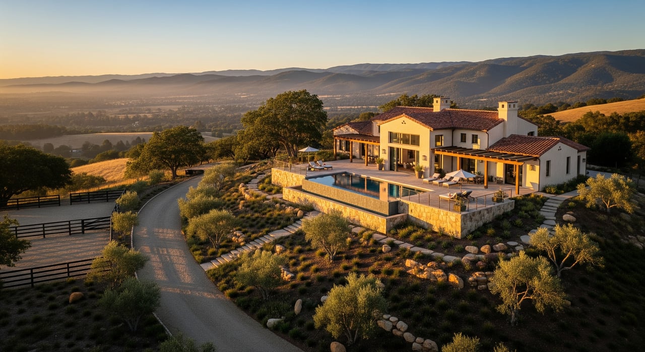
If you are drawn to wide-open views, privacy, and room to build a life outdoors, La Cresta is worth a closer look. Set on the Santa Rosa Plateau west of Murrieta and north of Temecula, this unincorporated, semi-rural area blends custom estates, equestrian properties, and hobby agriculture in a setting that feels removed yet connected to regional hubs. The plateau’s elevation typically ranges from roughly 2,100 to 2,500 feet, which shapes its climate, views, and daily rhythm according to topographic references. As a whole, the community spans thousands of acres with hundreds of large parcels and many miles of private roads maintained through local property associations per community materials. This guide gives you a clear, practical orientation so you can choose the pocket that fits your lifestyle and plan a confident purchase.
Why newcomers pick La Cresta
La Cresta appeals to buyers who want space, quiet, and a custom-home lifestyle without leaving the Temecula Valley. The plateau’s higher elevation offers long-range vistas, cooler evenings, and a calm, country feel. At the same time, you are within an easy drive of shopping, services, and freeway access to larger job centers. The adjacent Santa Rosa Plateau Ecological Reserve adds a backdrop of preserved open space and trail access for hiking, riding, and nature watching as described by the parks agency.
This guide focuses on how the area is organized, what daily life looks like, and the due diligence that matters for large-lot properties. You will learn a decision framework to compare pockets, plus a straightforward buying timeline so you can move from curiosity to a clear plan.
Neighborhood layout overview
How the area is organized
Think of La Cresta as a collection of distinct pockets rather than a single subdivision. Each pocket has its own parcel patterns, elevation band, and community guidelines. Across the plateau, properties tend to be acreage estates with rural uses and private roads. The overall footprint covers thousands of acres with hundreds of parcels and an extensive network of privately maintained lanes and trails per community sources. As you tour, you will notice shifts in spacing, vegetation, and road types that signal you have moved from one pocket to another.
Terrain and views
Elevation and topography drive the look and feel. Ridges and hilltops deliver panoramic sunrise and sunset views. Rolling terrain with oak woodlands can feel more sheltered and private. Higher spots experience more wind exposure and larger temperature swings, while lower draws may collect fog and morning dew. Siting matters: a home oriented for cross-breezes can feel different than one tucked behind a ridge. The plateau’s general elevation band is roughly 2,100 to 2,500 feet, and some highland pockets sit even higher based on topo references.
Community feel and pace
Some sections feel exceptionally quiet and secluded, with long drive entries and generous setbacks. Others offer a closer-knit rhythm where neighbors wave on daily rides and ranch chores. Private roads and trail systems foster an outdoor lifestyle at an unhurried pace. The right fit comes down to how much interaction you want day to day and your comfort with rural driving and upkeep.
Homes, land, and lifestyle
Property types and acreage
You will find custom homes on large parcels, single-level ranch houses, and multi-structure estates with barns, guest homes, and shops. Acreage brings benefits and responsibilities. More land can mean better privacy, room for animals or gardens, and space for future improvements. It also means planning for maintenance: fencing, gates, driveway surfaces, irrigation, tree care, and outbuilding upkeep. Many parcels were planned with rural uses in mind, and minimum lot sizes vary by pocket based on community guidelines.
Equestrian and rural uses
La Cresta supports a wide range of country living: horses, hobby orchards, small vineyards, and pasture. When you evaluate a property, consider practical layout. Barn and arena placement affect prevailing winds, drainage, and dust. Gentle slopes are useful for turnout and pasture management. For agriculture, pay attention to sun exposure, water access, and soil. If you plan to add structures or expand, check the parcel’s existing improvements and set a phased plan that matches your time and budget.
HOAs, CCRs, design rules
Different pockets on the plateau have their own property owner associations and recorded covenants. Some emphasize larger minimum lots and a more rustic aesthetic. Others lean into design review and uniform standards. The trade-off is simple: more guidelines can protect long-term look and feel, while more flexibility can allow for creative improvements. Before you fall in love with a property, review the current governing documents and fee schedules so you understand use permissions, setbacks, fencing rules, and any trail or road obligations. Many miles of private roads and community trails are maintained through these associations per community materials.
Access, schools, and services
Commuting and connectivity
Daily driving in La Cresta feels different than in a subdivision. Expect private roads, rural lanes, and changes in elevation. Travel times depend on weather, time of day, and your exact pocket. The plateau sits west of Murrieta with regional freeway access within a reasonable drive, making north and south commutes possible, though peak-hour traffic to larger job centers can be significant. If commuting matters, test the route at your typical departure and return times.
Schools and enrollment
Most properties in the area connect to nearby public school systems by address. Attendance lines can cross community pocket boundaries, which is why verification is essential. Use the county or district locator to look up the exact property address and confirm enrollment steps, documentation, and any program options that fit your student’s needs see the school district locator resource. If zoning is central to your decision, check at the start of your search, again when you write an offer, and once more before closing.
Utilities and providers
Rural utilities vary by property. Many homes use private wells for domestic and irrigation water, on-site septic systems, and propane for gas. Internet can range from fiber in select corridors to fixed wireless or satellite in more remote spots. Trash service, mail delivery, and package logistics also vary. During due diligence, confirm water source and well yield, septic permits and age, propane tank ownership vs. lease, internet options, and where deliveries typically occur.
Ownership costs and checks
Carrying costs basics
Plan for the usual core costs plus rural-specific line items. Create a budget that covers:
- Property taxes and any parcel-based assessments
- Homeowner’s insurance with a wildfire component where applicable
- Utilities including electricity, water or well power, propane, and internet
- Maintenance reserves for acreage: fencing, driveways, gate motors, trees, pumps, and outbuildings
- Association dues for private road and trail upkeep if applicable as community sources note
Land and infrastructure due diligence
Acreage properties reward thorough checks. Build your inspection list around:
- Title matters, easements, and access rights for private roads
- Well yield and water quality testing; pump age, storage tanks, and irrigation setup
- Septic inspection with tank location, leach field condition, and permit history
- Grading, drainage, and slope stability around structures and roads
- Outbuilding permits and intended use compliance
- Fencing lines, cross-fencing, and gate access for service providers
- Fire-readiness features like ignition-resistant vents, clear gutters, and accessible water sources
Risk, insurance, and safety
La Cresta sits within a wildland urban interface, and many parcels fall under state or local fire hazard maps. Review the current Fire Hazard Severity Zone designation for any address and understand defensible space rules, home-hardening expectations, and disclosure requirements per the State Fire Marshal. Insurance availability and pricing can change. Get quotes early and evaluate mitigation steps that may improve options.
Choose your best-fit pocket
Priorities and trade-offs
Start with a simple framework:
- Privacy vs. proximity to town services
- Paved approaches vs. rural roads
- Higher elevation views vs. day-to-day accessibility
- Strict guidelines and polished uniformity vs. more flexibility for improvements
- Existing equestrian or agricultural infrastructure vs. a clean slate
Scenarios and decision paths
- Equestrian-focused family: Look for functional barn placement, arena orientation, and sensible turnout areas. Prioritize water access, fencing, trailer-friendly driveways, and a comfortable commute to trainers or show venues.
- Work-from-home professional: Balance reliable internet and office space with quiet surroundings and inspiring views. Test connectivity at the property and confirm provider options.
- Low-maintenance estate seeker: Seek newer systems, simple landscape plans, and efficient layouts. Favor properties with recent well, septic, and roof updates to reduce near-term projects.
- Hobby farmer or vintner: Check sun exposure, soil, water storage, and frost risk. Evaluate topography for equipment access and safe staging.
How to compare options
Use a side-by-side checklist for each property:
- Lot characteristics: acreage, useable flat pads, sun, wind, views
- Access: road type, grade, drainage, and driveway design
- Systems: well yield, storage, septic capacity, electrical service, backup power
- Structures: home condition, outbuildings, permitted square footage, fire-hardening
- Guidelines: association rules, fees, and any architectural review process
- Maintenance: near-term replacements and annual upkeep tasks
Buying strategy and timeline
Prep and financing
Pre-approval is step one, but acreage adds a few specifics. Share property details with your lender early so they understand wells, septic, outbuildings, and appraisals for rural homes. Build a timeline that leaves room for specialized inspections and quotes. If you will keep animals or plant crops, sketch a phased plan and budget before you write an offer.
Touring and evaluation
Structure tours to sample different pockets at varied times of day. Drive in daylight first, then return at dusk to check lighting, temperature, and wind. If it rains, revisit to observe drainage. Walk the property lines, note slopes and pads, and identify where services enter the parcel. Photograph system labels and serial numbers so your inspector and insurer can quote accurately.
Offer, negotiation, and closing
Write an offer that secures access for all inspections and clearly sequences your contingencies. Prioritize water, septic, roof, electrical, fire-readiness, and permit verification. Use findings to negotiate repairs, credits, or price adjustments. Before you remove contingencies, revisit your core assumptions: commute, internet, water, and insurance. Keep your contractor and inspector notes organized so you can hit the ground running after closing.
Plan your next step
La Cresta rewards buyers who appreciate space, nature, and the satisfaction of a well-planned property. The right pocket depends on how you weigh privacy, access, elevation, and guidelines. With a clear framework and thorough due diligence, you can choose a home that fits both your day-to-day life and your long-term plans.
If you want a tailored walkthrough of La Cresta’s pockets and a data-driven look at your options, reach out to Jeff Engstrom. We will align your lifestyle goals with the right parcel, verify the details that matter, and guide you from first tour to confident closing.
FAQs
Where exactly is La Cresta, and what is the terrain like?
- It is an unincorporated, semi-rural area on the Santa Rosa Plateau west of Murrieta and north of Temecula, generally between about 2,100 and 2,500 feet in elevation, with ridges, rolling hills, and oak woodlands location overview and topo context.
How is La Cresta organized if it is not a single subdivision?
- The plateau comprises several pockets with their own parcel patterns, community guidelines, and private roads. Altogether it spans thousands of acres, hundreds of parcels, and many miles of privately maintained lanes and trails community snapshot.
What kinds of properties and uses are common?
- Custom homes on acreage with room for horses, hobby agriculture, and outbuildings. Evaluate layout, water access, and soil for your intended uses.
Are there HOAs or rules I should know about?
- Many pockets have property owner associations with recorded covenants. Review current rules, fees, and design guidelines before committing. Private road and trail upkeep is often funded through these associations community details.
How do I confirm school assignments for an address?
- Use the district’s address locator to verify attendance zones, then confirm enrollment steps and documentation for your student district locator.
What should I verify about utilities on a rural parcel?
- Confirm well yield and quality, septic permits and condition, propane setup, internet options, and whether the driveway and gates allow service access.
Is wildfire risk a factor on the plateau?
- Yes. Check the Fire Hazard Severity Zone designation for the address, review defensible space guidance, and obtain insurance quotes early State Fire Marshal resource.
What is the best way to compare different pockets?
- Use a simple matrix: privacy, road type, elevation, guidelines, existing improvements, and maintenance needs. Tour at different times of day and keep detailed notes.